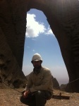
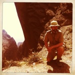
On our last full day in Kashgar, we arrange to travel towards one of the other main goals of this trip – the little visited Shipton’s Arch.
Eric Shipton was the senior mountaineering figure of his time, who led a number of Everest reconnaissance missions and, with long term partner and fellow intrepid adventurer Bill Tilman developed the idea of trim mountain climbing teams, rather than grand pack-animal borne retinues – thus undemocratically (albeit perhaps unintentionally) ruining climbing for the amateur with an aversion to high intensity fitness regimes.
Tilman himself was a prominent character who fought in both world wars, was the last recorded Westerner to cross the Wakhjir Pass from China into Afghanistan in 1947 and who lost his life, AET 79, on a sailing adventure in the Atlantic in 1977 – the same year as Shipton died.
The trip over the Wakhjir for Tilman came as he was ‘walking home’ to India after a visit to Shipton at Kashgar. Shipton was consul at Kashgar from 1940-42 and then was the final consul for Britain (pre subcontinental independence and partition) 1946-47. In between times he was cereal or agricultural adviser in both Persia and then Hungary. An improbable string of appointments and titles that is a little difficult, superficially, to reconcile to his known skills and interests but presumably gave him wide scope for other activities during wartime.
Xinjiang at the time was immersed in an almost historically impenetrable swirling mess of changing allegiance as armies from the Chinese nationalist government, their notional governor-appointee in Urumqi, Hui (or Tungan) armies from Gansu, Uyghurs and Soviets did battle while constantly changing teams. It seems to be about as close to a game of Risk (between players who know they will not play together again) as one can get.
In addition, from at least the 30s there were rumours that Lawrence of Arabia was waiting just over the Karakorum to the south to swoop in and seize control of the province and prevent it falling to full enemy control the way Mongolia had to Soviets and Manchuria to the Japanese. Fleming and Maillart encountered this rumour, that may have been fuelled by Lawrence, under a pseudonym, actually being posted with the RAF in Peshawar for ‘frontier policing’ i.e. using planes to quell the Pathan tribes via village strafing. Tempora mutantur… Lawrence was swiftly sent back to the UK after word got out and around the local community of his presence but any British designs on Xinjiang would require a rather detailed look through India Office papers.
There may have been some interest. Billy McLean, Special Operations Executive officer who served with distinction in Albania and East Africa, came to Kashgar as military adviser in 1945 – though notionally focussed on Japan rather than the now Soviet allies.
Anyway, back to Shipton. From his writings (Mountains of Tartary etc) about his time in Kashgar it appears his main focussed continued to be alpinism. He and Tilman tried to climb the now very busy Muztagh Ata but did not quite make it. Shipton was however the first outside to discover Shipton’s Arch, in 1947. This is the world’s largest natural formed arch and stands arund 1200 feet clear of the ground on one side – about the height of the Empire State Building – and around 180 feet wide.
Shipton apparently came across it having heard about it from locals. It sits in the very dense and irregular Black Mountains that separate China and Kyrgyzstan. The nearest town is Artush.
We had read, as with the southern Tarim route, that access was difficult and few knew the eact location. Indeed the Arch disappeared from international knowledge altogether following the inital discovery, until 2000 when a National Geographic trip rediscovered it.
Now however an improved autoroute is being built towards the Kyrgyz border. Unlike the borders with Afghanistan and Tajikistan, this is a normalised one with third country traffic, such as tourists, allowed to pass, and China has been making a major economic impact on Kyrgyrzstan that it seems set to consolidate.
At Artush we stop to buy some massive Kyrgyz bread – like Uyghur but about twice the diameter. The mountains then shortly come into view. The irregularity in heights of the peaks and each peak’s individual steepness means it barely looks like a traditional range. Kashgar itself sits at around 1300m but we drive to around 2700m before clambering out, around 75-80 km northwest of Kashgar and just by the Kyrgyz border.

By this stage we have left the highway and headed directly into the hills but the signs of widespread knowledge of the site now are abundant. For starters, it is signposted; and this signage indicates its relatively Chinese name – Heaven’s Gate – about as original as calling an English pub the Red Lion. In Uyghur it is known as “Pierced Rock”.
Then at the end of the hill road, we come across a large carpark in the throes of completion, and matching visitor centre. Signs have also been erected indicating that tickets need to be bought but apparently this will not come into effect until next year when the facilities are completed. There are no tour buses as yet but presumably there will soon be a gondola or one of those golf kart trains to take people up to the arch itself.
As it is now, there is a walk of about an hour up to view it, winding up what looks like an old glacier or river canyon – rocky underfoot such as is found along braided rivers and steeply eroded on both sides. There are semi-permanent metal steps in place in the tightest spots, where once there used to be bamboo ladders, and the climb is safe and fairly obvious even if unmarked.

There is one group from Gansu undertaking it in traditional Chinese city wear of black slacks, short sleeve shirts and loafers but having slightly more appropriate footwear would probably have been an advantage to them (as it is they omit to take water and have to call down to their driver to bring some up to them at the top of the climb). They love the pith helmets though, so all judgement is withheld.

After about 40 mins the arch first comes into view. The canyon narrows and then rises to a steep back wall and the arch sits at the top of this. It looks large from a distance, but it is only the top 200 feet or so that can be seen from this angle as the slope up to it blocks the actual full drop of the arch it is sort of like the arch sits against a separate hill that then slopes down to form the canyon that we are in. Approaching from the other side to see the full extent is apparently very difficult and takes a great deal of mountaineering or canyoning expertise – after one has even found the right access point and route.

Climbing the final steep grass bank to sit under the arch gives you a much better feeling for its size. The grassy slope deteriorates into loose gravel and then banks down towards the sides of the arch. the slope of this bank restricts views to the bottom but what can be seen is dizzying, especially if one looks swiftly up then back again. There is a highly unworthy looking safety chain that has indeed been pulled out of the ground at one point.

Through the arch, off to the right can be seen in the far distance the town of Kashgar – obscured in the haze of heat and dust.
The pictures, as so often, barely do it justice. For starters, it is impossible to get the top of the arch and any decent quantity of what can be seen of the drop into the one shot.
It is however a great pleasure to be standing up here, above Kashgar, more or less on our own.
For what it is worth based on an IPhone compass (backed up by Casio at least as to altitude) we are:
– At 2940m
– The arch piercing is directly NW to SE i.e. we look SE back towards Kashgar – Co-ordinates of 39.6603 N; 75.5234 E
- image43
- image44


You must be logged in to post a comment.